
Svaneti · 4,710 m · Greater Caucasus
Mount Ushba
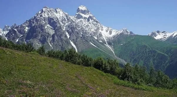
The twin-summited icon of Svaneti — nearly 3,000 m of rock and ice above the valleys. You do not have to be a climber to stand beneath it.
On this page
Where Ushba is
Ushba stands in Upper Svaneti, in the north-west of Georgia, close to Georgia's northern border. It rises at the head of the Dolra valley, with the village of Mazeri directly beneath its southern flanks and Mestia, the regional centre, about 25 km to the east.
The mountain sits slightly forward of the main Caucasus watershed, which is why it dominates the skyline. From almost anywhere around Mestia — the town, the ridges above it, the Mulakhi villages — the twin summits are the first thing your eye finds.
Why it is famous
Two things. The shape: a double summit, North 4,690 m and South 4,710 m, split by a saddle, forming a silhouette unlike anything else in the range — the comparison to the Matterhorn is for once deserved. And the reputation: despite being short of 5,000 m, Ushba is considered one of the hardest ascents in the Caucasus. Svan tradition has long treated it as a mountain best left alone.
The best viewpoints
- Koruldi Lakes — the classic panorama above Mestia: twin summits, the basin below, a line of Caucasus peaks in one sweep. About 15 km return and 1,300 m of ascent on foot, or a half day if you drive the rough track.
- Mazeri — the closest view from a road, right under the south face at about 1,500 m. No walking needed. Best in the morning, before cloud builds.
- Shdugra Waterfall trail — from Mazeri deeper into the cirque, Ushba directly overhead. Roughly 4–5 hours return, moderate.
- Guli Pass — about 2,950 m, the most dramatic close-up of the north-west aspect. A demanding full day, better with a guide.
- Mestia–Ushguli trek, day 2 — the ridge above Zhabeshi puts Ushba and Tetnuldi in front of you at once. Many walkers rate it the best view of the four days.
Can you climb it?
Almost certainly not, and we would rather say so than sell a fantasy. Ushba is a technical objective at the top end of Caucasus difficulty — sustained steep rock and ice, serious exposure, long committing days, real hazard from rockfall and weather. It is not a mountain a fit hiker can be guided up. What is open to visitors: the viewpoints, the foot of the Ushba glacier from Mazeri, and the Guli Pass crossing. Genuine alpinists can talk to us on the mountaineering page.
When to go
Mid-June to early October. Snow lingers on the higher approaches into June and the passes close with the first serious autumn snowfall. One practical warning: Ushba makes its own weather and is often wrapped in cloud when the valley is clear, with cloud building through the afternoon. Go early, and give yourself several days — visitors who allow one afternoon often leave without ever seeing it. September is the sweet spot.
How to get there
Nearby
FAQ
Good to know
01How high is Mount Ushba?+
South summit 4,710 m, North summit 4,690 m. It is not Georgia's highest — that is Shkhara at 5,193 m — but it is the most recognisable.
02Can tourists climb it?+
No. A serious technical ascent for experienced mountaineers only. Hikers can reach viewpoints and the foot of the glacier, but not the summit.
03Is Ushba harder than Mont Blanc?+
Technically yes, considerably — lower, but far more demanding, with sustained technical ground and greater objective danger.
04How many days do I need?+
Two to three days based in Mestia or Mazeri gives a realistic chance of clear weather plus one good viewpoint walk. One day is a gamble. Day hikes to every viewpoint on this page — Koruldi ridge, Mazeri and the Shdugra trail — plus transfers up the Dolra valley.